С 30-го марта по 2-ое апреля в Москве будет проходить очередная специализированная выставка GeoTECH, посвещенная технологиям и оборудованию для инженерной геологии и геофизики.
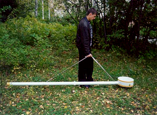
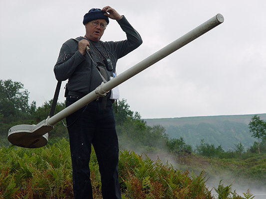
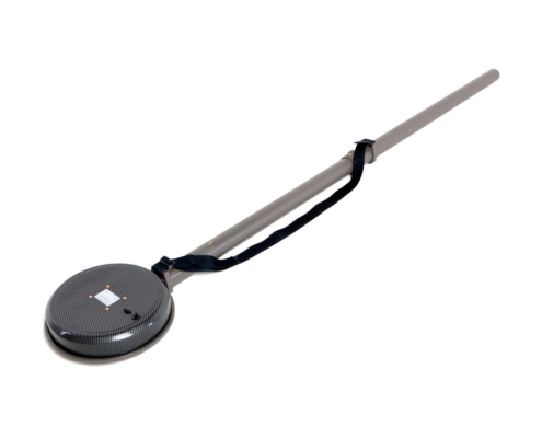
На данной выставке будет представлен электромагнитный сканер Немфис.
Тематика выставки:
Технологии и оборудование для инженерной геофизики:
Георадиолокация,
Электроразведка,
Малоглубинная сейсморазведка,
Геоакустика,
Грави-магниторазведка;
Комплексные исследования при решении задач инженерной геологии, гидрогеологии, геокриологии, экологии и археологии;
Оборудование для инженерно-геологических исследований;
�?зыскания при поиске и разведке полезных ископаемых;
�?зыскания под капитальное строительство;
�?зыскания на линейных объектах (автомобильные и железные дороги, трубопроводы)
Геофизическая аппаратура для малоглубинных инженерных исследований;
Аппаратные и программные средства для сбора, обработки и интерпретации геофизических данных.
Выставка будет проводиться по адресу:
Москва, ЭЦ «Сокольники».
[singlepic id=94 w= h= float=center]
[singlepic id=92 w= h= float=center]

"Рады приветствовать Вас на нашем сайте. От лица сотрудников благодарю за проявленный интерес.
Основной состав нашей команды - это выходцы из Российской Академии Наук, что обеспечивает
кратчайший путь научных разработок из лабораторий к применению в производственной геофизике."
Юрий Манштейн, директор, кандидат технических наук.
Геофизическая аппаратура

Электротомография
Многоканальная электроразведочная аппаратура для работ методом сопротивлений и вызванной поляризации

Многочастотное электромагнитное (индукционное) профилирование

Георадиотомография
Многоракурсное георадиолокационное зондирование

О нас
SiberGeo — объединяет российских производителей аппаратуры методов электроразведки и индукционного профилирования, а также аппаратурно-программного комплекса многопозиционного радиолокационного зондирования (георадиотомограф). Компания осуществляет внедрение применяемых геофизических методов в различные сферы народного хозяйства; обеспечение информационной, методической и сервисной поддержки по продукции; участие в научно-исследовательской деятельности в области геофизики; проведение работ с применением различных геофизических методов, а также разработку и внедрение методик комплексирования данных.
Основная линейка продукции SiberGeo:
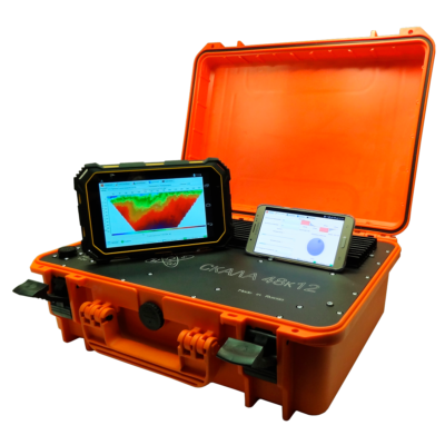
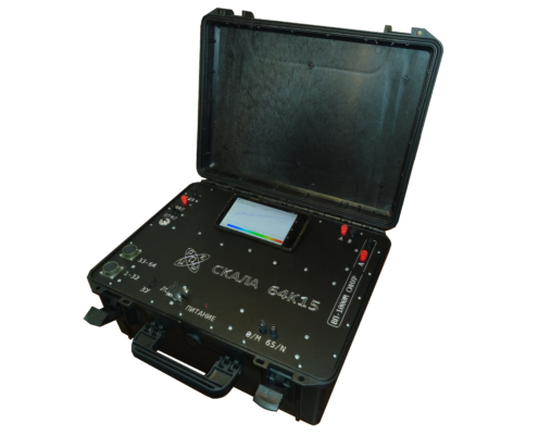
— аппаратура электротомографии серии «Скала» (Скала 32К4, Скала 48К12, Скала 64К15);
— многочастотные электромагнитные профайлеры — «АЭМП-14» и «Геовизер»;
— система многоракурсного георадиолокационного зондирования — «ГРТ-XX».
Основное применение
�?мея многолетний опыт решения различных геофизических задач, мы воплотили в жизнь наше видение тенденции развития оборудования для повышения эффективности проводимых исследований.
Археология
- Локализация и анализ археологических объектов — захоронений, артефактов, предметов быта;
- Картографирование древних сооружений — определение местоположения фундамента и стен разрушенных зданий;
- Локализация археологических объектов;
- Мониторинг состояния скрытых под грунтом памятников архитектуры;
- Детальное исследование археологических объектов.
Образование
- Гидрогеология;
- Археология;
- Палеонтология;
- Агрономия;
- Экология;
- Вулканология;
- Геофизика;
и др.
Точное земледелие
- Оценка концентрации минеральных удобрений;
- Оценка земель сельскохозяйственного назначения;
- Оценка фертильности почвы;
- Сезонный мониторинг динамики изменения св-в почвы;
- �?сследования состояния грунта, определения зон трещиноватости, обводнения.
Гидрогеология
- Сезонный мониторинг динамики изменения свойств подземных вод;
- Поиск и локализация подземных вод;
- Картирование подземных вод и их загрязнения;
- Поиск источников соли и пресной воды.
Обнаружение коммуникаций
- Мониторинг состояния подземных коммуникаций;
- Поиск и локализация источников утечки воды в подземных трубопроводах;
- Определение местоположения подземных коммуникаций, сооружений и т.д .;
- Картирование подземных коммуникаций.
- Поиск криминальных захоронений, тайников, взрывных устройств, людей под лавинами;
- Выявление несанкционированных врезок в магистральные трубопроводы;
- Поиск источника утечки и оценка количества утечки из трубопроводов.
Автомобильные и ж/д дороги, аэродромы
-
Определение толщин и структуры конструктивных слоев дорожной одежды, железнодорожнойнасыпи, элементов ВПП, рулевых дорожек аэродромов;
-
Определение геометрии кровли естественного основания и балластной призмы;
-
Картирование подземных коммуникаций;— контроль соответствия строения дорожной одежды, железнодорожной насыпи,взлетно-посадочных полос проектной документации;
-
Выявление разуплотненных и обводненных участков;
-
�?зучение особенностей армирования бетонных плит покрытия;
-
�?зучение инженерно-геологических условий участков, подверженных деформациям;
-
�?зучение инженерно-геологической обстановки территорий, прилегающих к аэродромам.
Управление экологическими рисками
- Агроэкология;
- Анализ влияния техногенных факторов;
- Экологический надзор;
- Мониторинг потенциально опасных объектов;
- Управление экологическими рисками;
- Экологическая оценка загрязнения почвы горюче-смазочными материалами;
- Обнаружение и локализация захоронений промышленных отходов любого химического состава.
Коммунальное хозяйство и строительство
- Поиск и локализация различных дефектов в деревянных, кирпичных, железобетонных строительных конструкциях;
- Обнаружение арматуры, скрытой проводки, инженерных коммуникаций;
- Уточнение инженерно-геологических и гидрогеологических условий строительных площадок;
- Поиск скрытых дефектов в стенах инженерных сооружений, шахт, тоннелей, в опорах и потолках;
- Мониторинг состояния подземного пространства при профилактических работах по гидроиспытанию сетей водоснабжения.
- Проектирование объектов капитального строительства;
- Проведение геофизических работ на этапе инженерно-
геологических изысканий под новое строительство совместно с бурением и методами полевых испытаний грунтов; - Проведение мониторинга сооружений, попадающих в зону влияния будущего строительства;
- Обследование состояния грунтового основания, фундаментов и строительных конструкций сооружений, попадающих в зону влияния строительства;
- Обследование состояния подземных сооружений (тоннелей, коллекторов, резервуаров и т.п.);
- Проведение геофизических работ в ходе строительства сооружений;
- Проведение геофизических работ в ходе эксплуатации сооружений;
- �?зучение вероятных причин деформации сооружений;
- Поиск утечек и подтоплений из водонесущих коммуникаций;
- �?сследование характера развития негативных техногенных
процессов
Этот раздел содержит информацию о компании,
карту дилеров и полезные ссылки
Информация
SiberGeo — осуществляет лицензионное производство геофизического оборудования, разработанного совместно со специалистами Российской академии наук и Томского университета. Компания реализует продукцию методов электроразведки, индукционного профилирования и георадиолокации; осуществляет внедрение методов электроразведки в различные сферы народного хозяйства, а также обеспечивает информационную, методическую и сервисную поддержку по продукции.
Также компания осуществляет научно-исследовательскую деятельность в области геофизики, производит работы с применением различных методов электроразведки, а также проводит комплекс мероприятий, направленных на усовершенствование продукции.
Компания предлагает комплексные геолого-геофизические сервисные услуги, включая бурение, лабораторные и полевые исследования.
Организуя поставку высокотехнологичного оборудования – нашей компанией проводится предварительный анализ сферы применения; первичная консультация о возможных вариантах реализации, поставленной клиентом задачи; обучение работе с оборудованием; осуществляется гарантийное и послегарантийное обслуживание.
Наша цель – развитие долгосрочных взаимовыгодных отношений с партнерами и клиентами. Предоставление профессиональной информационной и технической поддержки. Участие в приоритетных направлениях развития научно-технологического комплекса России.
Detailed products history
- Multi-frequency electromagnetic induction profilers
The first prototype of the EM-I profiler with 14 frequencies was assembled in 1996 (EMS#0), but because of the then crisis situation in the country, the intention to introduce and mass-produce electromagnetic scanners were left until better times. In 2001, in the laboratory of electromagnetic fields of the Institute of Petroleum Geology and Geophysics. A.A. Trofimuka SB RAS (IPGG SB RAS) a second prototype device (EMS#1) was assembled, from which the development of production and testing of the methodology began.
In 2008 was commercial release of multi-frequency electromagnetic induction profiler «NEMFIS» (EMS#05). The experience of using frequency sounding with the «NEMFIS» hardware-software complex shows that a methodological approach to the study of subsurface space to a depth of a few meters on the basis of high-quality signal reconstructions is informative and cost-effective. A comparative analysis of this technique with existing foreign technologies based on the induction methods has revealed a number of significant advantages, such as noise reduction, high resolution and sensitivity.
At 2012 — was released first «AEMP-14» (EMS#20) with completely new electronic plates and cover.
Unique properties of the device:
— the ability to obtain information in the form of geoelectric maps and profiles of the apparent resistivity values in real time on Android or Windows mobile;
— applicability in high level of electromagnetic interference conditions;
— performance in conditions of extremely low ground resistance.
First compact profiler “Geovizer” was released in 2014, it implements the induction multi-frequency sounding method, and allows contactless measuring of the underground situation. As a result of measuring, it is possible to obtain the spatial level distribution of the secondary field signal from the ground till 3 meters depth. Three-frequency EM-I profiler “Geovizer” allows profiling on any set of 3 fixed frequencies in the 12.5 – 111 kHz range, including the measuring with global coordinates automatic associating.
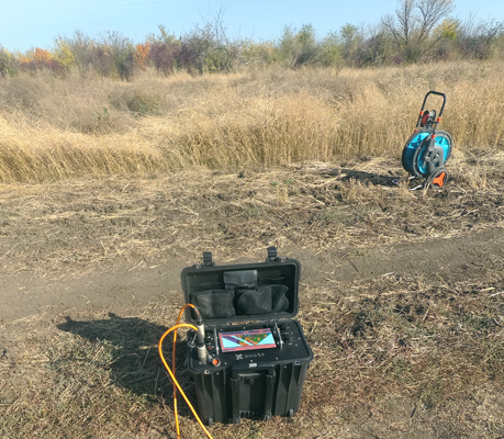
Multi-electrode electrical resistivity & induced polarization imaging instruments
In 2009 the core staff of the company LLC «KB Electrometry» in cooperate with the Institute of Petroleum Geology and Geophysics A.A. Trofimuka SB RAS (IPGG SB RAS) developed the «SibER 48» — multi-electrode instrument, which was designed to perform electrical exploration using resistivity and induced polarization methods with the measuring modes of electrical profiling, vertical electrical sounding, and electrical tomography. There is a switch for electromechanical relays, a generator and a selective millivoltmeter in the case. For long profiles, the “roll-up” mode is implemented with the transfer of the first segment of the multi-electrode cable of the previous arrangement to the place of the second in the next one. SibER 48 has built-in software that allows you to:
— program switching to work with 2D tomography;
— ensure the safety of data during power failures;
— disconnect any electrodes;
— provide flexible control of equipment.
Subsequently in 2014 there was developed 16x channels and 64-electrode instrument for electrical resistivity & induced polarization imaging “SibER 64”. The core of the hardware is an integrated processor unit with Linux OS. Control of the unit organises by 10 inches touch screen, which allows operator to perform all operator work without using a personal computer. Synchronization with an external PC is carried out using a standard USB cable. The internal source generator of a bipolar pulses sequence has 200W power. There is also possibility of using an external generator 1KW+. Thanks to the high-performance processor, touch screen and advanced interface, the equipment layout allows interactively programming measurement protocols, viewing, monitoring and preliminary processing of the measured data.
In 2017, KB Electrometry presented last developments — the Geovizer induction profiler and 48-electrodes 15x measuring channels electrical resistivity & induced polarization imaging instruments SibER 48K12.
In 2019, KB Electrometry brought to the market a new model 64-electrodes 15x measuring channels electrical resistivity & induced polarization imaging instruments SibER 64K15 with the ability to synchronise with an external source VP-1000M.
In January 2020, the company introduced a new version of the Xeres control software, now in the 4th version the user sets the operating voltage, indeed the current. This eliminates the occurrence of emergency situations because of a high ground resistance difference on electrodes. The logging measurement functionality and a new diagnostic module for conducting operational tests of internal nodes of the system are also added.
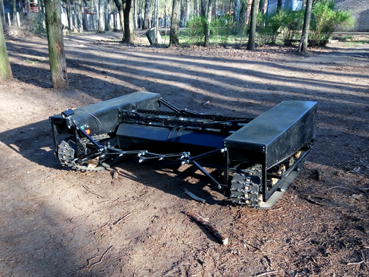
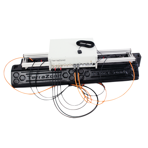
Multi-array ground radio imaging system
The concept of a hardware-software complex for 3D radio imaging was approved in 2006. Since 2012, the development of the multi-array ground radio imaging system «GRT-XX» (GeoRadioTomograph) has been carried out jointly with a group of specialists from the Siberian Physical-Technical Institute (TSU), programmers and specialized engineers.
In 2015, the first prototype of a 16-channel chirp signal generator that work in the 500 MHz — 2000 MHz range was created, which allows multi-angle sounding with trace digitization at 256 samples.
In April 2017 the prototype of a 32-channel generator with pre-processing on board and data transmission via Fast Ethernet (100 Mbit/s) protocol was presented.
In March 2018, at the “Georadar-2018” conference, as part of a field demonstration, a working set of GRT-23 equipment (24 antenna elements; scanning width ~ 2m) installed at the road laboratory was shown. Thanks to the integrated module based on FPGU controllers — the data processing speed was significantly increased — data collection and processing from the entire line at a measurement density of 10 cm was carried out at the speed up to 45 km/h (up to 80 km/h if using 6 measurement channels) with digitization of a trace signal on 512 samples.
In August 2018, a new version of the device was released, with an improved protocol for transmitting data via Gigabit Ethernet, providing digitization of the trace signal at 1024 samples and data collection at speeds up to 80+ km/h with a measurement density of 5 cm when using 32 antenna elements.
In July 2019, a new version of the hardware generator firmware was released, which additionally provided switching options for the measurement mode using the common midpoint method (CMP).
In August 2019, the integration of the .trz format into the GeoReader software package was completed. The results of the data processing obtained during the GPRs testing at the GC Avtodor test field in the summer of 2019, organised by the RosdorNII, demonstrate the high efficiency of the operation of software algorithms for calculating the depth section according to GOST R 58349-2019.
In January 2020, it was possible to significantly improve the quality of data due to the refinement of the antenna modules, as well as the introduction of the primary calibration technique and compensation of the hardware function.
In 2020, the company announces a new model of high frequency radio imaging system — GRT-81, designed to get three-dimensional radio images with a resolution of 15×15 mm according to plan and <2 mm in depth, in particular, to measure the thickness of the upper layer of the road surface with high accuracy, as well as to build the function of changing the relative density of the investigated environment.
2002
ЭМС#1
Первый предсерийный вариант 14-частотного электромагнитного индукционного профайлера EMS#1
2008
Немфис
Начало серийного производства аппаратуры электромагнитного индукционного профилирования NEMFIS (EMS#05)
2010
Скала 48 (SibER 48)
Начало серийного выпуска электроразведочной аппаратуры для работ методом сопротивлений и вызванной поляризации “Скала 48”
2012
АЭМП-14
Начало серийного производства аппаратуры электромагнитного индукционного профилирования AEMP-14 (EMS#20)
2013
Скала 64 (SibER 64)
Начало серийного выпуска 64-x электродной, 16-ти канальной электроразведочной аппаратуры для работ методом сопротивлений и вызванной поляризации “Скала 64”
2014
Геовизер
Первый прототип компактной трех частотной аппаратуры электромагнитного индукционного профилирования «Геовизер»
2015
ГРТ-2
Первый прототип аппаратуры многоракурсной георадиолокации ГРТ-2
2017
АЭМП-14 HW:04
Обновление схемотехники и элементов корпуса аппаратуры АЭМП-14, существенные оптимизации технологических процессов на производстве, повышение эффективности контроля качества выпускаемой продукции.
2017
Скала 48К12 (SibER 48K12)
Начало серийного производства 48-ми электродной, 12-ти канальной электроразведочной аппаратуры для работ методом сопротивлений и вызванной поляризации «Скала48К12» (SibER 48K12).
2018
Геовизер 4.5
Начало серийного производства компактной аппаратуры электромагнитного индукционного профилирования «Геовизер» (Geovizer)
2017
ГРТ-XX
Начало серийного производства аппаратуры многоракурсной георадиолокации (георадиотомограф) ГРТ-2X
2019
Скала 64К15 (SibER 64K15)
Начало серийного производства 64-х электродной, 15-ти канальной электроразведочной аппаратуры для работ методом сопротивлений и вызванной поляризации «Скала64К15» (SibER 64K15).
2020
ГРТ-81
Первый прототип компактной аппаратуры многоракурсной георадиолокации высокого разрешения ГРТ-81
2020
Скала 32К4 (SibER 32K4)
Начало серийного производства 32-х электродной, 4-х канальной электроразведочной аппаратуры для работ методом сопротивлений и вызванной поляризации «Скала32К4» (SibER 32K4).

Associations and specific resources:
The European Association of Geoscientists and Engineers (EAGE)
EarthDoc Online Geoscience Database
Our regional partners:
Geostudi Astier S.r.l. (Italy)
NALADA, S.R.O. (Czech Republic)
iGEO — Technological Solutions for Secure Environment (Norway)
PT. Multi Prima Technology (Indonesia)
CLICK — Center of Learning Innovation and Knowledge (Morocco)
Специалисты нашей компании проводят комплексные геофизические исследования среды методами
электроразведки, сейсморазведки, георадиолокации и магнитометрии.
Задачи решаемые нашей командой специалистов:
– подготовка строительных площадок — локализация мусора, контроль состояния среды;
– инженерно-геологические изыскания;
– археологические исследования;
– локализация аварий инженерных коммуникаций коммунального хозяйства (места обводнений);
– исследование почвы;
– контроль уровня загрязнения вод;
– и другие работы связанные с геофизическим исследованием среды.
Для получения консультации по применению методов, а также для заказа наших услуг используйте форму
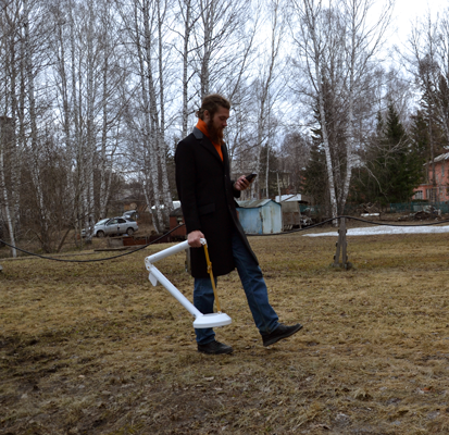
Multi-frequency electromagnetic induction profilers
The first prototype of the EM-I profiler with 14 frequencies was assembled in 1996 (EMS#0), but because of the then crisis situation in the country, the intention to introduce and mass-produce electromagnetic scanners were left until better times. In 2001, in the laboratory of electromagnetic fields of the Institute of Petroleum Geology and Geophysics. A.A. Trofimuka SB RAS (IPGG SB RAS) a second prototype device (EMS#1) was assembled, from which the development of production and testing of the methodology began.
In 2008 was commercial release of multi-frequency electromagnetic induction profiler "NEMFIS" (EMS#05). The experience of using frequency sounding with the "NEMFIS" hardware-software complex shows that a methodological approach to the study of subsurface space to a depth of a few meters on the basis of high-quality signal reconstructions is informative and cost-effective. A comparative analysis of this technique with existing foreign technologies based on the induction methods has revealed a number of significant advantages, such as noise reduction, high resolution and sensitivity.
At 2012 - was released first "AEMP-14" (EMS#20) with completely new electronic plates and cover.
Unique properties of the device:
- the ability to obtain information in the form of geoelectric maps and profiles of the apparent resistivity values in real time on Android or Windows mobile;
- applicability in high level of electromagnetic interference conditions;
- performance in conditions of extremely low ground resistance.
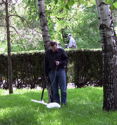
First compact profiler “Geovizer” was released in 2014, it implements the induction multi-frequency sounding method, and allows contactless measuring of the underground situation. As a result of measuring, it is possible to obtain the spatial level distribution of the secondary field signal from the ground till 3 meters depth. Three-frequency EM-I profiler “Geovizer” allows profiling on any set of 3 fixed frequencies in the 12.5 – 111 kHz range, including the measuring with global coordinates automatic associating.
Multi-electrode electrical resistivity & induced polarization imaging instruments
In 2009 the core staff of the company LLC "KB Electrometry" in cooperate with the Institute of Petroleum Geology and Geophysics A.A. Trofimuka SB RAS (IPGG SB RAS) developed the "SibER 48" - multi-electrode instrument, which was designed to perform electrical exploration using resistivity and induced polarization methods with the measuring modes of electrical profiling, vertical electrical sounding, and electrical tomography. There is a switch for electromechanical relays, a generator and a selective millivoltmeter in the case. For long profiles, the “roll-up” mode is implemented with the transfer of the first segment of the multi-electrode cable of the previous arrangement to the place of the second in the next one. SibER 48 has built-in software that allows you to:
- program switching to work with 2D tomography;
- ensure the safety of data during power failures;
- disconnect any electrodes;
- provide flexible control of equipment.
Subsequently in 2014 there was developed 16x channels and 64-electrode instrument for electrical resistivity & induced polarization imaging “SibER 64”. The core of the hardware is an integrated processor unit with Linux OS. Control of the unit organises by 10 inches touch screen, which allows operator to perform all operator work without using a personal computer. Synchronization with an external PC is carried out using a standard USB cable. The internal source generator of a bipolar pulses sequence has 200W power. There is also possibility of using an external generator 1KW+. Thanks to the high-performance processor, touch screen and advanced interface, the equipment layout allows interactively programming measurement protocols, viewing, monitoring and preliminary processing of the measured data.
In 2017, KB Electrometry presented last developments - the Geovizer induction profiler and 48-electrodes 15x measuring channels electrical resistivity & induced polarization imaging instruments SibER 48K12.
In 2019, KB Electrometry brought to the market a new model 64-electrodes 15x measuring channels electrical resistivity & induced polarization imaging instruments SibER 64K15 with the ability to synchronise with an external source VP-1000M.
In January 2020, the company introduced a new version of the Xeres control software, now in the 4th version the user sets the operating voltage, indeed the current. This eliminates the occurrence of emergency situations because of a high ground resistance difference on electrodes. The logging measurement functionality and a new diagnostic module for conducting operational tests of internal nodes of the system are also added.
/Users/Diman/Desktop/product_release.txt
Multi-array ground radio imaging system
The concept of a hardware-software complex for 3D radio imaging was approved in 2006. Since 2012, the development of the multi-array ground radio imaging system "GRT-XX" (GeoRadioTomograph) has been carried out jointly with a group of specialists from the Siberian Physical-Technical Institute (TSU), programmers and specialized engineers.
In 2015, the first prototype of a 16-channel chirp signal generator that work in the 500 MHz - 2000 MHz range was created, which allows multi-angle sounding with trace digitization at 256 samples.
In April 2017 the prototype of a 32-channel generator with pre-processing on board and data transmission via Fast Ethernet (100 Mbit/s) protocol was presented.
In March 2018, at the “Georadar-2018” conference, as part of a field demonstration, a working set of GRT-23 equipment (24 antenna elements; scanning width ~ 2m) installed at the road laboratory was shown. Thanks to the integrated module based on FPGU controllers - the data processing speed was significantly increased - data collection and processing from the entire line at a measurement density of 10 cm was carried out at the speed up to 45 km/h (up to 80 km/h if using 6 measurement channels) with digitization of a trace signal on 512 samples.
In August 2018, a new version of the device was released, with an improved protocol for transmitting data via Gigabit Ethernet, providing digitization of the trace signal at 1024 samples and data collection at speeds up to 80+ km/h with a measurement density of 5 cm when using 32 antenna elements.
In July 2019, a new version of the hardware generator firmware was released, which additionally provided switching options for the measurement mode using the common midpoint method (CMP).
In August 2019, the integration of the .trz format into the GeoReader software package was completed. The results of the data processing obtained during the GPRs testing at the GC Avtodor test field in the summer of 2019, organised by the RosdorNII, demonstrate the high efficiency of the operation of software algorithms for calculating the depth section according to GOST R 58349-2019.
In January 2020, it was possible to significantly improve the quality of data due to the refinement of the antenna modules, as well as the introduction of the primary calibration technique and compensation of the hardware function.
In 2020, the company announces a new model of high frequency radio imaging system - GRT-81, designed to get three-dimensional radio images with a resolution of 15x15 mm according to plan and <2 mm in depth, in particular, to measure the thickness of the upper layer of the road surface with high accuracy, as well as to build the function of changing the relative density of the investigated environment.